When we see lakes in our city, we don’t often see the undercurrent reality of the water body. Lakes have become a spot for scenic appreciation and leisure. To understand the ecosystem of the water networks and lakes I propose a framework to diagnose the conditions of lake which will help to design interventions in and around the lakes. To understand specific examples, I have taken the case of Bangalore city. My stay in Bangalore was very short, that of seven months, but every day my trip back to home from work would end by walking past Sankey tank, one of the many lakes in the city which has become an urban hotspot for recreational activities. Coming from a city like Ahmedabad, strolling by lakeside in the evenings was the most valuable experience that the city could offer me and I have my own association with it, but this idea of the meaning of a water body for people always intrigued me.

Earlier on, shortage of water often gave rise to ingenious techniques to collect and store rainwater, and replenish and revive groundwater. The intricate systems of connected water reservoirs and canals in Dholavira water ponds in Rajasthan which thrived its trading markets and the much-celebrated step-wells of Gujarat, are examples that show the significance of spatial manifestation of water right from its source to outlet along the entire water network. They were not just isolated water-bowls collecting water, but rather deeply rooted in everyday life of society. Water infrastructures were interwoven with people’s lives and thus their perception of water was not only as an ecological resource but also had socio-cultural value.
Similarly, lakes in Bangalore were not merely sites of recreation. Along with its historic importance as irrigation tanks to capture and hold water, the lakes would serve many communities like the dhobis, horticulturists, fishermen, whose livelihood depended on water, a critical resource. The lakes were very important for the local economy as they were used for domestic needs, to grow year-round crops and fishing. Local communities have been guardians of the lakes, they designed their own norms to regulate the access and appropriate the lakes. Such a relationship with the lake bred physical manifestation along the water network in the form of wetlands, wells, hand pumps, bund walls, ecology around lakes, temples, etc.
However, this is not the case with modern infrastructure. Due to rapid urbanization, increasing influx of people and the large demand for land, lakes have become a contested entity. The city depends on piped water supply and so the lakes’ land would rather be used for development. Bangalore has more than 2000 lakes which are now decaying and polluting as their utilitarian purpose is lost. It is important to understand this change in utility of the infrastructure.
“Modern infrastructure for water, being hidden from view and dissociated from experience, has been erased from our urban sensibilities, the connection with water and the environment. The components that bring water have been converted into mono-functional infrastructure.” (Arya)
Different people with different socio-economic backgrounds, hold varied perceptions and value for lakes. Today, the lake has become an isolated artifact with a fence all around which imposes restricted access to a different group of people. Earlier, physical markers on and around the lake were softer and allowed a different range of activities to take place for various kinds of people. The sense of ownership has been altered. Thus with urbanization, lakes appear to be undergoing a shift in public perception as pristine ‘natural’ spaces that need protection and enclosure, excluding visitors belonging to lower-income groups, who use the lake for domestic purposes, fishing and other activities critical to them. (Nagendra)
The process of shifting natural and man-made boundaries of the water network has led to disputes regarding the ownership of lakes, which in turn raises the question of who are actors responsible for its conservation and who holds a stake in the water body. To derive this new set of relationships it is important to decode the ecosystem of lake at three different scales. Micro scale (lake and immediate surrounding), miso scale (watershed area) and macro-scale (water network of city).
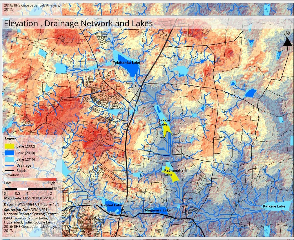
At microscale, the lake is not a monofunctional water holding bowl, it is rather a system of ecological processes of wetlands, lakes, and canals. This raises critical questions on the lake and its immediate boundary, how is the boundary defined and who defines it. Depending upon the season, each part of this system will expand and contract to change its boundaries over a natural process. For example, in Nagwara lake, the water catchment shown in year 2016 is greater than year 2010, this suggests that there was the consideration of wetlands in the system. In 2010, the water boundary was small, a large chunk near the canal, through which there is inlet of water from the upstream Hebbal lake was wetlands. In the current scenario, the boundary of wetlands is hazy as the whole area is marked as a lake. This changes the stake of various actors and their incentives for association with the lake. As the wetlands reduce, the water entering from Hebbal to Nagwara is not filtered, hence the water becomes less on account of it getting polluted and mixed with sewage water through the drains. This eventually leads to the drying up of the lake and the canal and creates an opportunity for other stakeholders to contest the land. In the case of Nagawara lake, Karle Special Economic Zone (SEZ) was developed.

At Nagawara, multi-storey buildings tower over a depression of land overrun by weeds and the entire site is abuzz with construction activity. It is hard to believe that the area, which falls in the Karle Special Economic Zone, is classified in village records as a rajakaluve (main canal), but locals insist that a wide storm water drain (SWD) diverted water into the Nagawara lake nearby before the buildings came up. The claim in defense was that the lakes are defunct and appropriate for development . Such re-inscriptions of water as land, or the denial of water, have led to the destruction or disappearance of water bodies across urban centers in India. (Coelho). A micro scale diagnosis of boundaries helps to understand the natural ecosystem necessary to sustain the water holding capacity of the lake.
Miso scale is the watershed network. For example, during the rejuvenation project of Rechenahalli lake, wetlands were designed on the 100-acre site of lake for primary and secondary treatment of water. While at Jakkur lake which is upstream of Rechenahalli, there is an STP plant which is supposed to clean the water from surrounding residential areas and the overflow through the canal which in turn flows into Rechenahalli lake. The STP plant at Jakkur lake does not function due to its high-power consumption and therefore the canal which carries the water to Rechenahalli has become the sewage line. Polluted water enters the wetlands at Rechenahalli, but they are not capable of cleaning such a large amount of water, which makes them ill-functional. Miso scale is critical to understand the lake beyond its water holding boundary and the larger watershed network. Miso scale also helps critically think about the micro scale. For example, during the conservation work of Rechenahalli lake the kere (water tank) and rajakaluve (canal) which brings water from the upstream lake was fenced. The kere is now securely bunded by concrete wall and has become an isolated water collecting bowl, as opposed to a sloping bed with different depths which sustained its own ecology. The sluice mechanism and the linear bund which is now replaced by a ring bund both used to control the flow of water to downstream lake. But now both are lost. This disturbs the whole channel of lakes. This disrupts the ecological logic and leads to flooding on the one hand and depletion of groundwater on the other as well as the loss of urban biodiversity.
At macro scale, for example in Bangalore, the availability of alternate source of Cauvery water has made the dependency on the lake network significantly less. This has also given rise to a complex economy of using water as a commodity through the water tanker business. Water tanker business runs parallelly to the state, supplying water to places where the state fails to. However, social protection, sale of unauthorized land, electoral lobbying and providing welfare, are the resultant practices of this business transversal in nature to the informality produced by the state. For providing water through this apparatus, bore wells are dug deeper and deeper and this has led to the exhaustion of natural aquifers around the existing lakes. Eventually leading to a threat to conservation of the natural lakes.
The changing nature of dependence of actors on natural resources have given rise to the debate on water being a commodity versus an ecology. Certain elements of the lake stay and certain change. In these negotiations, the cost of environmental conservation is paid by, the marginal or urban poor. There is no element of environmental justice which provides a lens to look across these three scales horizontally along with ecological conservation. The new set of relationships developed for urban ecology should also generate economic benefits or livelihood for these communities who pay the cost.
The perspective of three scales came from need to understand the complex interconnections of water with governance, social identity and economy. But this is a diagnostic approach. Looking at three scales will help dwelling into the problem. This framework will help to analyze the problem from an immediate boundary to city boundary. Questions like, when does the fish in the lake at micro scale becomes livelihood at miso scale. How can centralized and decentralized infrastructure be designed in three scales. How does the state leverage empty land for real estate development? Should the lakes be fenced around like Rechannahali lake, converted to water bowls and the land freed up for real estate growth? How does this framework work for citizens groups and government bodies? The intention of this essay is to open up new modes of engagement with the problem and thereby think of new modes of practice to deal with urban lakes.
The three scales lead to the fundamental question — what scale should the lakes be governed by? Should it be from micro to macro or vice versa? The nomenclature around the source of water including storm water or drainage water, pumped water, wetlands and lakes and making boundaries around each has given rise to innumerable governing bodies. And each of these bodies have their own incentives for conservation of lakes. Such a diagnostic tool, helps to break down the problem and gives insights on all the bodies involved.
[ii] https://roha75.wordpress.com/2014/05/26/rachenahalli-containment-of-a-kere-a-visual-essay/
